GEOGRAPHY of POLYNESIA
Groups of islands sprinkled in the South Pacific, the French Polynesia
occupies a surface of earths emerged of the order of 4000 Km² (lagoon
understood): it is little to the look of the 4 millions of Km2 of its total surperficie.
The population has been estimated to 208000 inhabitants in 1993, 237800 in 1998 and 262000 in 2004.
Approximate distribution of the inhabitants: 12% live in the
Islands Under the wind,
75% in Islands-of-the-Wind, 6% in the archipelago of the Tuamotus, 4% in the
Islands Marchioness, and 3% in the Southern Islands.
The life expectancy increases and pass 70 years currently. Tahiti and its
vicinities account about 150000 inhabitants. The population distributes itself
more or less so: 68% of Polynesian (maohis), 12% of European (which essentially
French), 5% of Asian, and 15% of "demis" (half-caste Polynesian-Europeans or
Polynesian-Asians). Close to 50% of the population has less than 20 years and
unemployment goes up since the stop of Mururoa.
The tahitians trains a beautiful welded people and they are reputed for their
hospitality, their kindness, and their natural "joie de vivre".
French and tahitian are the two officials languages, but English is also very
fluently used in the hotels and the stores.
Resources of Polynesia: the tourism remains the sector the more carrier (20% of
the GDP). The black pearl, produced exclusively in French Polynesia, constitutes
the second source of incomes. The fishing all as the industry (whose main
activity is the transformation) are two sectors in full flight. Also, the
culture of the "nono" (medicinal plant) and its transformation became recently
rather activities lucrative.
![]()
It's composed of 118 islands in 5 archipelagos :
The archipelago of the TUAMOTU.
Its sumptuous submarine funds make of this archipelago the paradise of the scuba
diving and the same stroke a high world place of meeting of the enthusiasts of
the diving. Essentially composed of atolls of which the beauty of the beaches
and lagoons is unequalled. There are 78 atolls of the Tuamotus, spread on a few
1500 Km and close to 20 000 Km² of marine territory, between Tahiti and the
Marchioness.
The 15500 inhabitants about the archipelago are called " Paumotus ."
The economic activities: the tourist activity (hotels and clubs of diving), the
production of black pearls, the fishing, the pickup of shellfish (intended to
the manufacture of the necklaces) the harvest of coprah....
Rangiroa and Manihis are the islands the more frequented with in more an inn big
status and of the centers of diving of level and international renown.
![]()
This archipelago (neighbor of the Tuamotus) account a few more of 1000 inhabitants. The island of Mangareva, regroup the majority of the population. The activities economic of the Gambiers are: a little tourism, the production of pearl (its main resource), the engraving on mother of pearl, the production of honey and its handicraft.
The main islands : Mangareva, Rikitea....
The main islands are : Nuku-Hiva, Tahuata, Fatu Hiva, Hiva-Oa, Ua-Pou, Ua Huka,....)
![]()
![]()
Very
spread in length, it represents the last earths lived to the south of the
Pacific. It is composed of 5 islands and some islets of which the total surface
reached about 140 Kms2, lost in the immensity of the ocean. The nearest island
is to a distance of 600 km about to the south of Tahiti. Nearer of the zones
moderated of the globe, these islands have a more moderate climate, therefore
cooler; and of the reliefs more rounded.
Its a few 6600 inhabitants about sell their life to the rhythm of the traditions
and the traditional activities: fishing, agricultural exploitations on fertile
earths (cultures of vegetables, of manioc, of orange trees, of coffee trees, as
well as the classic avocados, coconut trees, pineapples and vanilleses). The
islands of the archipelago of the Southern, less frequented that the other
islands nearer from the equator, possess few hotels and tourist comforts. One
finds there, however, of charming pensions and lodgings at the inhabitant for
"more authentic" stays.
Les îles sont : Rurutu, Tubuai, Raivavae, Rapa et
Rimatara.
![]()
The two origins of Polynesia
Islands :
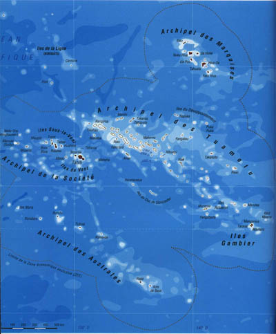
![]() Map of the 5 Archipelagos
Map of the 5 Archipelagos
they are descended of corallin formations (more or less in circles), delimiting an interior lagoon that communicates with the ocean by means of passes (as Rangiroa)
or are formed by former underground volcanos that ended up emerging. This type of islands, higher arrange relief and can pass the 2 000 m of altitude (the Mount Orohena on Tahiti reaches 2232 m
|
Map of the 5 Archipelagos
|
|
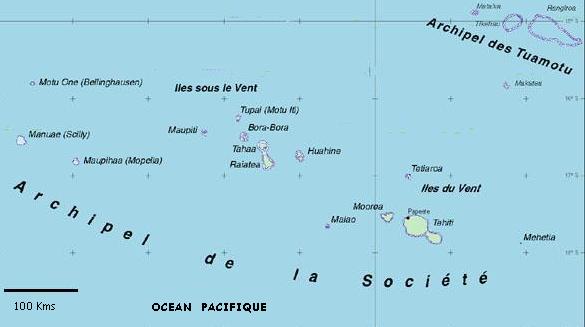
Archipelagos map of the Islands of the Society
![]()
|
|
|
Archipelagos map of the Islands of the Society
Site
optimisé pour IE5/6 en 1024 x 768
Images Copyright:
Some pictures on this site were taken from the Internet, and therefore are believed to be public domain.
They appear here as I have found them on the internet. However, if you own the copyrights of any picture found on this site,
please e-mail me.
Une partie des images de ce site viennent d'Internet, ainsi donc, je crois qu'elles appartiennent au domaine
public.
Elles apparaissent ici telles qu'elles ont été trouvées sur Internet. Cependant, si vous connaissez des copyrights
sur certaines d'entre elles, n'hésitez pas à me le signaler par e-mail.
|
|
Bora Bora |

.